![](/images/other/stat-length.png)
![Trail Walking Woluwe-Saint-Lambert - Sint-Lambrechts-Woluwe - East End - Photo](https://media.geolcdn.com/t/1900/400/0051dc60-9f5b-4678-9397-61cb886ba6d1.jpg&format=pjpeg&maxdim=2)
East End
GaetanHouart
User
![Length](/images/other/stat-length.png)
Length
18 km
![Max alt](https://static1.geolcdn.com/siteimages/upload/files/1508320355ic_sort_altitude_max_24dp.png)
Max alt
96 m
![Uphill gradient](https://static1.geolcdn.com/siteimages/upload/files/1508320355ic_sort_den_pos_24dp.png)
Uphill gradient
243 m
![Km-Effort](/images/other/stat-length.png)
Km-Effort
21 km
![Min alt](https://static1.geolcdn.com/siteimages/upload/files/1508320355ic_sort_altitude_min_24dp.png)
Min alt
37 m
![Downhill gradient](https://static1.geolcdn.com/siteimages/upload/files/1508320355ic_sort_den_neg_24dp.png)
Downhill gradient
256 m
![Boucle](https://static1.geolcdn.com/siteimages/upload/files/16400158638029165_repeat_loop_refresh_sync_direction_icon.png)
Boucle
No
Creation date :
2021-05-15 16:05:28.583
Updated on :
2021-05-15 16:07:50.796
![Walking](https://static1.geolcdn.com/sitytour/trail-icons/101.png)
4h49
Difficulty : Very difficult
![Scan this QR Code to open this trail in the SityTrail application](https://capi.geolives.com/qq0zvz2zws4bq2lad0pu/sitytour/trails/2788011/qr.png?size=200)
FREE GPS app for hiking
About
Trail Walking of 18 km to be discovered at Brussels-Capital, Unknown, Woluwe-Saint-Lambert - Sint-Lambrechts-Woluwe. This trail is proposed by GaetanHouart.
Description
En fin de promenade, prendre le Tram 7 de la Station Louis Bertrand vers Montgomery et à Montgomery, le métro jusque Vandervelde...
Positioning
Country:
Belgium
Region :
Brussels-Capital
Department/Province :
Unknown
Municipality :
Woluwe-Saint-Lambert - Sint-Lambrechts-Woluwe
Location:
Woluwe-Saint-Lambert
Start:(Dec)
Start:(UTM)
601762 ; 5633834 (31U) N.
Comments
Trails nearby
![Trail Walking Auderghem - Oudergem - RB-BXL-10-Rac02 - Photo](https://media.geolcdn.com/t/375/260/ext.jpg?maxdim=2&url=https%3A%2F%2Fservices.sitytrail.com%2FGeolivesWS%2FDownloadMedia.ashx%3FTrailID%3D247907%26Media%3Db30f5581-2af5-47b0-aca2-8f9cddfbea28.jpg)
![Walking Walking](https://static1.geolcdn.com/sitytour/trail-icons/101.png)
RB-BXL-10-Rac02
Walking
Easy
(10)
Auderghem - Oudergem,
Brussels-Capital,
Unknown,
Belgium
![](/images/other/stat-length.png)
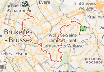
13.6 km | 16.2 km-effort
3h 40min
![](https://static1.geolcdn.com/siteimages/upload/files/16400158638029165_repeat_loop_refresh_sync_direction_icon.png)
Yes
![Trail Walking Auderghem - Oudergem - RB-Br-09 Raccourci 2 - Photo](https://media.geolcdn.com/t/375/260/ext.jpg?maxdim=2&url=https%3A%2F%2Fservices.sitytrail.com%2FGeolivesWS%2FDownloadMedia.ashx%3FTrailID%3D247903%26Media%3D4f2f6ef8-5647-4df5-b72e-d8a55c5e5b6f.jpg)
![Walking Walking](https://static1.geolcdn.com/sitytour/trail-icons/101.png)
RB-Br-09 Raccourci 2
Walking
Easy
(9)
Auderghem - Oudergem,
Brussels-Capital,
Unknown,
Belgium
![](/images/other/stat-length.png)
15.3 km | 18 km-effort
4h 5min
![](https://static1.geolcdn.com/siteimages/upload/files/16400158638029165_repeat_loop_refresh_sync_direction_icon.png)
Yes
![Trail Walking Auderghem - Oudergem - RB-Br-09 - Photo](https://media.geolcdn.com/t/375/260/ext.jpg?maxdim=2&url=https%3A%2F%2Fservices.sitytrail.com%2FGeolivesWS%2FDownloadMedia.ashx%3FTrailID%3D247899%26Media%3D7b6d3a4f-3999-4d35-8f7d-f23163489b77.jpg)
![Walking Walking](https://static1.geolcdn.com/sitytour/trail-icons/101.png)
RB-Br-09
Walking
Medium
(8)
Auderghem - Oudergem,
Brussels-Capital,
Unknown,
Belgium
![](/images/other/stat-length.png)
20 km | 25 km-effort
5h 34min
![](https://static1.geolcdn.com/siteimages/upload/files/16400158638029165_repeat_loop_refresh_sync_direction_icon.png)
Yes
![Trail Walking Auderghem - Oudergem - RB-BXL-10 - Photo](https://media.geolcdn.com/t/375/260/ext.jpg?maxdim=2&url=https%3A%2F%2Fservices.sitytrail.com%2FGeolivesWS%2FDownloadMedia.ashx%3FTrailID%3D247904%26Media%3Db30f5581-2af5-47b0-aca2-8f9cddfbea28.jpg)
![Walking Walking](https://static1.geolcdn.com/sitytour/trail-icons/101.png)
RB-BXL-10
Walking
Medium
(4)
Auderghem - Oudergem,
Brussels-Capital,
Unknown,
Belgium
![](/images/other/stat-length.png)
21 km | 25 km-effort
5h 38min
![](https://static1.geolcdn.com/siteimages/upload/files/16400158638029165_repeat_loop_refresh_sync_direction_icon.png)
Yes
![Trail Walking Auderghem - Oudergem - RB-Br-09 Raccourci 1 - Photo](https://media.geolcdn.com/t/375/260/ext.jpg?maxdim=2&url=https%3A%2F%2Fservices.sitytrail.com%2FGeolivesWS%2FDownloadMedia.ashx%3FTrailID%3D247901%26Media%3D4f2f6ef8-5647-4df5-b72e-d8a55c5e5b6f.jpg)
![Walking Walking](https://static1.geolcdn.com/sitytour/trail-icons/101.png)
RB-Br-09 Raccourci 1
Walking
Easy
(4)
Auderghem - Oudergem,
Brussels-Capital,
Unknown,
Belgium
![](/images/other/stat-length.png)
16 km | 19.1 km-effort
4h 20min
![](https://static1.geolcdn.com/siteimages/upload/files/16400158638029165_repeat_loop_refresh_sync_direction_icon.png)
Yes
![Trail Walking Tervuren - Tervuren Leefdaal 22 km - Photo](https://media.geolcdn.com/t/375/260/ext.jpg?maxdim=2&url=https%3A%2F%2Fservices.sitytrail.com%2FGeolivesWS%2FDownloadMedia.ashx%3FTrailID%3D1084200%26Media%3D20181213150951.jpg)
![Walking Walking](https://static1.geolcdn.com/sitytour/trail-icons/101.png)
Tervuren Leefdaal 22 km
Walking
Easy
(1)
Tervuren,
Flanders,
Flemish Brabant,
Belgium
![](/images/other/stat-length.png)
23 km | 27 km-effort
5h 24min
![](https://static1.geolcdn.com/siteimages/upload/files/16400158638029165_repeat_loop_refresh_sync_direction_icon.png)
Yes
![Trail Cycle Wezembeek-Oppem - ox2 - Photo](https://media.geolcdn.com/t/375/260/ext.jpg?maxdim=2&url=https%3A%2F%2Fservices.sitytrail.com%2FGeolivesWS%2FDownloadMedia.ashx%3FTrailID%3D151603%26Media%3D20120904141505.jpg)
![Cycle Cycle](https://static1.geolcdn.com/sitytour/trail-icons/200.png)
ox2
Cycle
Easy
(1)
Wezembeek-Oppem,
Flanders,
Flemish Brabant,
Belgium
![](/images/other/stat-length.png)
13.7 km | 15.2 km-effort
48min
![](https://static1.geolcdn.com/siteimages/upload/files/16400158638029165_repeat_loop_refresh_sync_direction_icon.png)
Yes
![Trail On foot Tervuren - Warandewandeling - Photo](https://media.geolcdn.com/t/375/260/87c065a8-2320-4622-bcf3-9c4a54024d3f.jpeg&format=jpg&maxdim=2)
![On foot On foot](https://static1.geolcdn.com/sitytour/trail-icons/100.png)
Warandewandeling
On foot
Easy
Tervuren,
Flanders,
Flemish Brabant,
Belgium
![](/images/other/stat-length.png)
4.9 km | 6 km-effort
1h 21min
![](https://static1.geolcdn.com/siteimages/upload/files/16400158638029165_repeat_loop_refresh_sync_direction_icon.png)
No
![Trail On foot Tervuren - Arboretumwandeling - Photo](https://media.geolcdn.com/t/375/260/deef483e-a724-4529-a3ed-af2727caf4be.jpeg&format=jpg&maxdim=2)
![On foot On foot](https://static1.geolcdn.com/sitytour/trail-icons/100.png)
Arboretumwandeling
On foot
Easy
(1)
Tervuren,
Flanders,
Flemish Brabant,
Belgium
![](/images/other/stat-length.png)
7.1 km | 8.5 km-effort
1h 55min
![](https://static1.geolcdn.com/siteimages/upload/files/16400158638029165_repeat_loop_refresh_sync_direction_icon.png)
Yes